Friday, February 22: Somewhat cloudy to begin with, becoming showery and, especially in exposed areas, windy
Tramping: 13.3 km
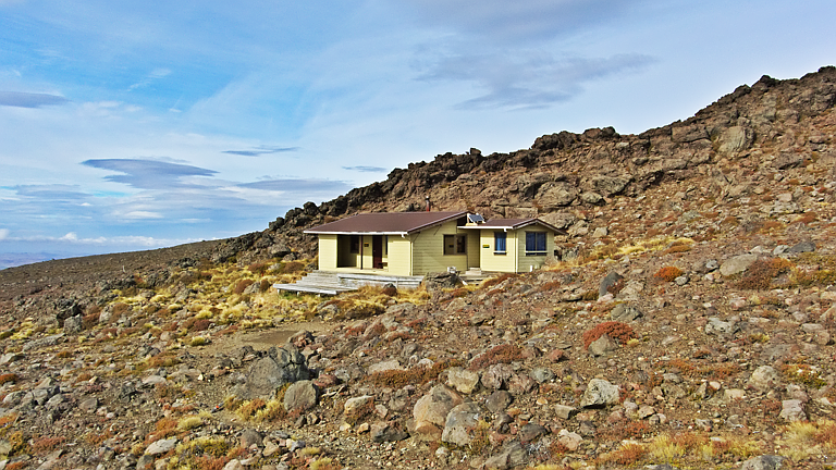
Waihohonu Hut (Doc, Great Walks, $36)
Sleep was unusually fragmented, possibly because the pillow kept on deflating. There was some snoring from the other two male inhabitants but it was survivable, possibly due to the high winds that were buffeting the hut./p>
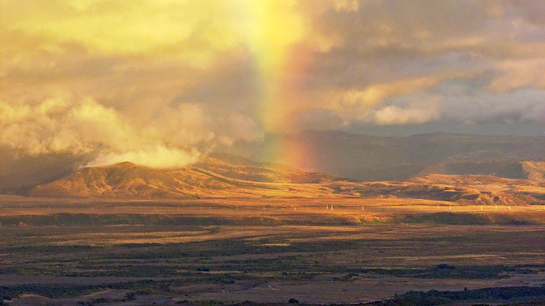
It was also quite a bright night because of the full moon. Around dawn I was awake for the final time and noticed oranges and reds of the impending sunrise, and decided it was good enough for a timelapse. As I set my camera up I was soon joined by Trevor & then Jeff & Rachael, and it really was only 6:30. Read more…
Thursday, February 21: Sunny to begin with, a couple of sprinkles and then some moderate showers
Tramping: 17.4 km
Rangipo Hut (Doc, $15)
Alan was up very early & off to work, long before I had to get up, but at around 7:00 I thought it would be enough time to throw stuff into the suitcase and complete packing for the tramp.
About the only things that weren’t up to scratch were that the compass hasn’t been calibrated, and it looks like I put in two hairbrushes; also the tripod should have been stripped of the gimbal attachment & the straps.
All was packed up & Jo and A. were on their way when I went out to the street to await my chauffeur, and Alan was already on his way back home. My driver had a couple of tips for me and we were soon at the drop-off point. He checked with his office about the return details so everything is in the green zone. Read more…
Monday, February 18: Cloudy to begin with, becoming hot & sunny
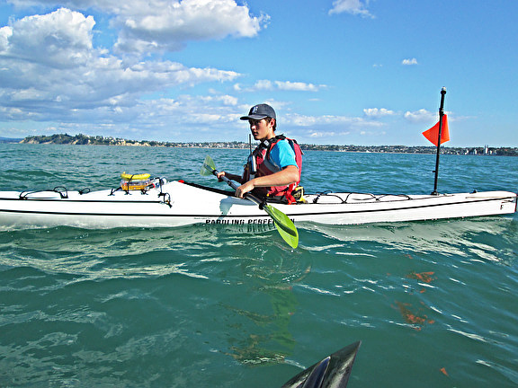
Kayaking: 20.2 km
Walking: 5.2 km
Tieke Kainga Marae (Doc, $32)
I had woken up once at around 1:00 and the one set of AA batteries had been charged completely. I then saw to it that the other set went into the charger. Apart from that, the combination of airbed + leaky pillow worked a small percentage of the time. Even though I was in the sleeping bag it did feel cold, although I myself was quite warm. In any case got some sleep and awoke around 6:30 to birdsong and the humming of wasps.
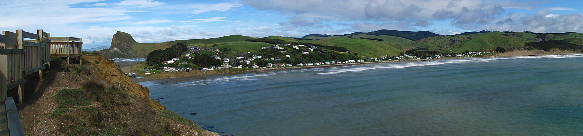
All the food was gradually disappearing & breakfast was quickly dealt with. Then the long trek with the stuff down to the boat, and getting ready to go. Everything worked as planned and I was quite proud of my start before 9:00. Progress was also quite rapid and I was a little surprised when “The Rock” turned up, complete with a cyclist awaiting his jet boat on top. It was much larger than what I had in memory, and much more daunting. How those dozens of Canadians managed to moor here is beyond imagination. Anyway I wanted to do the right thing and disembark at Mangapurua Stream. Had to find it first, it was perhaps a little further than the 500 m mentioned elsewhere. Anyway I was up the creek, and there was a nice landing place where I didn’t need to tie up the boat. Decided I would do some brackets of the Bridge to Nowhere, that meant dismantling the gimbal & tripod (good practice) and with lunch in the bag I set off first for the landing where I had a chat with the cyclist, and then to the Bridge itself. Quite a long walk, but fun anyway. Went to the lookout and took a couple of shots, then onto the bridge. Shots from either side, then lunch as two couples, one German, the other Belgian, then a whole troop of tourists including our cyclist arrived for their lunch with a tour guide.
Slide Show
Click on the image to stop/start the animation
A couple of brackets from the bridge were taken as well, then I was back along the path to the stream. By the way, the sidetrack between the stream and the main track is marked as closed (under construction) and had two very steep step sections more like ladders that had to be taken backwards on the way down. Noticed the jetboat (source of the tour guide & tourists) moored at the mouth of the stream, then set about getting my equipment working on the boat again. Boat had to be dragged a little way to the river, then I was set to go.
Youtube Video
The river here is less vigorous, and the sweeping amphitheaters give way to milder hills. Was overtaken by three jetboats and at the first sight of real farmland (some banks look like they could be or were once used for grazing) Tieke turned up, and I was the first arrival. No sign of anyone present, although cleaning devices for the floor were propped up here and there and all the windows were open. Sent off a spot OK to Gavin, then flicked through some of the pictures. Stability looks good, contrast is quite high, position is also quite good. Dragged all of my stuff up except the tent and at 3:45 claimed a bunk and started today’s chores, which involved airing the sleeping bag, drying some sox and undies, and starting on the diary.
Interactive Map
Easy paddling day and a brief walk. GPS quality: 30/30, coverage: 100% Change to tramping track Can’t see map? Click here!
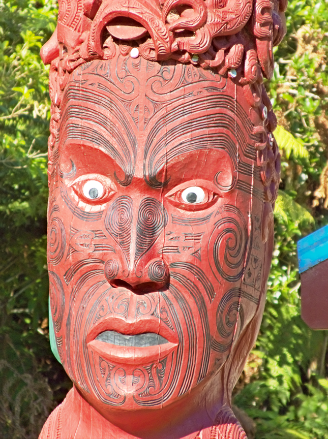
In the meantime the Belgian couple arrived, and bit later the warden, Boyd, who is quite a source of pseudoscientific folklore (Kangen water). Will now see about photographing the faces on the tekoteko before dinner.
More people arrived and Boyd put them all (!) into the dormitories instead of tents, so tents were dried and packed up again. He also provided a powhiri of sorts around 6:00 with little speeches of his own in Te Reo & English, then asked us to contribute a word or two & I took the lead by telling everyone about the birds that I had seen along the way and nearly everyone else followed suite. It was getting quite late for dinner, but mine (rice, instant noodles & tomato for a change) took only twenty minutes and was just as quickly consumed. Chatted away with Manfred and his wife from Zürich and am now fully considering a plan for tomorrow. One set of batteries was marked as “dead” although they must have been full, so the first step apart from boiling water will be to see what happens when I put them into the powerbank again. Then I need a shooting plan and a rapids plan for tomorrow.
Sunday, February 10: Completely clear skies very early, a couple of clouds turning up later in the morning & by late afternoon only a few land clouds
Walking: 8.6 km
Kayaking: 14.0 km
Nadia’s
Sleep was quite fragmented and when I was awake at 6:00 I could hear bellbirds. Short contemplation led me to the conclusion that I might record them – or at least attempt to in the quiet of a Sunday morning, so I got out the voice recorder and went downstairs to leave it out on the balcony.
The time needed to be reset on the device (not quite accurately achieved without glasses or a clear mind) but it was recording OK, so that was worth the effort. Slept another hour after that then had to buy some stuff for breakfast before such could be partaken of. Read more…
Sunday, September 23: Fine and sunny to begin with, becoming increasingly clouded over in the course of the day
Hiking: 27.1 km
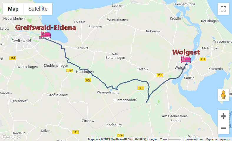
Home
Was greeted by the host on leaving my room on the way to breakfast, and a woman was attentively studying the Bett&Bike certificate that this place had. When I had turned into the breakfast room, he turned to her and said, “Früshstück ist auch für Sie fertig” to which she replied, “No capito”, and I felt I was called upon the translate at least “Frühstück” into Italian for her, so I seized the moment, looked at her and said, “Colazione” to which she looked rather relieved.
Harbor on the Peene, WolgastAnyway breakfast was a big deal here: Four bread rolls, a slice of bread, sausage, cheese, yoghurt, a sliced kiwi, some wedges of various fruit and capsicum, an egg, some whole cocktail tomatoes and grapes. I decided that everything that could (or would have to) be thrown away was either to be eaten on the spot, or packed away for lunch.
Before our Italian lady got too carried away with my Italian, I asked her whether she spoke English, and apologised for my musician’s Italian (which she eventually got). She was from Tuscany, cycling around. The host noticing that I was communicating with her, bought out some aluminium foil for wrapping up the bread rolls in, and asked me to translate for her that we could pack up what we couldn’t eat in the foil, which I did. I was busy making some rolls ready for lunch when she came over to my table and made motions to use the foil, but I noticed she had very little idea how to tear off a sheet (surely they have aluminium foil in Italy!). The trick, of course, is to start with a small tear on one side and let the sharp edge do the cutting. But she thought the sheet might tear if uniform force was applied and couldn’t seem to see the sharp edge on the package. Read more…
Saturday, September 22: Fine but cold to begin with, increasing patchy cloud during the day and a couple of showers in the late afternoon
Hiking: 34.9 km
Pension am Peeneufer, Badstubenstr. 24, 17438 Wolgast, double as single with ensuite and breakfast, wifi (€49)
Up bright and early to have what little was being threatened for breakfast, and organise some stuff for along the track. Turned out there was more than the one slice of bread on offer, so all three could be had with jam, and the bread rolls occupied with cheese and sausage could be stashed away for lunch. There was OJ in addition to the coffee, and an egg as well. Had everything packed and ready to go – the host rather belatedly gave me my change from last night, and as I was leaving only the couple in the adjacent room were left to having their breakfast.
Went down to the supermarket in an attempt to redeem two of the soft drink bottles, to no avail, and bought a 1.5 L bottle of raspberry lemonade for a change. GPS tracker seemed to be working fine, except that the USB cover, which had thoroughly detached itself at the beginning of the trip is now missing, presumed dead. Not much of a loss, as it was always difficult to get on and stay on. I started walking out of town along the road. A bit of storm damage was lying around. The markers stopped fairly abruptly after leaving town and were absent for the next few km. Read more…
Friday, September 21: Fine and warm to begin with, strong gusts of wind and bits of dust storms during the course of the day, just before the end of the hike, rain
Hiking: 28.6 km
R. Biedenweg, Am Bierbach 1, double room as single, shower, toilet, use of fridge, with breakfast (€37.6)
Was unable to sleep much beyond 6:15 this morning, but lay in bed awaiting enough light to go to breakfast. Once that had been dealt with, I checked my email for today’s exact address and sent the hosts an email advising of my arrival time. Everything packed up just nicely, and I had plenty of time to go to the supermarket for today’s softdrinks, and to get to the bus station, where there was only the one bus that was waiting, and with a couple of minutes before scheduled leaving, take on the three passengers.
Church in ReinbergI had decided on Reinberg as the starting point for today, and a sign along the old cobblestone road parallel to the modern road proved me right – where cyclists might have started descending towards Stahlbrode, there was a detour sign in place saying keep straight ahead. No other signs around as to where this detour started. After just on an hour I was in Kirchdorf, where there was one sign, then it was up to me and map-reading my GoogleEarth extracts. In one of the outskirts of Jeeser (and a number of places today seemed to consist only of isolated outskirts) I discovered a railway station with regular services (at least more regular than the bus services in this part of the world), so that would be an alternative break point, if you needed to get to either Stralsund or Greifswald). Further down the road (and much of today’s section was along various roads) Jager turned up with two markers, and that was the last of the markers for a long time to come. Read more…
Thursday, September 20: Cloudy very early in the morning, becoming quite fine, clouding over in the evening
Im Grünen
Hiking: 28.5 km
Some delivery truck had arrived with goods for the supermarket @ around 3:00, which briefly woke me. Apart from that I was around the block to breakfast just after 7:30, as I had a bus to catch, or at least order and catch. The proprietor briefly showed me the washing machine, and I returned to my room to try to get a skype call through to the transport agency for today’s bus. The first couple of calls ended in a “busy” message and loop back to the menu. I waited for a bit, then repeated the call and got through. My bus for today was ordered, but the gent on the other end of the line couldn’t give me any details about where to change buses, for that I would have to ask the bus driver himself. With that organised, I packed up all my stuff and went down to the supermarket to replenish a bottle of lemonade.
Straslund ChurchyardThen it was a long march through town. I had chosen the “blue” route (the latest .gpx file that I could find, which Georget – after some sanity checks for simpler files – eventually converted to .kml), which seemed to go down the main road (Frankenwall, Frankendamm, Rostocker Chaussee, where it seemed to join company with the “red” version – which covers all of the German section). Not any signs – even of a cycle track – could be seen and consulted my map to find where to get off, should I otherwise miss the opportunity. Just as that point a sign turned up for the Hansa Path, which was not helpful, and the path I was looking for went through Devin. Just before the hotel a cycle path did appear to join the paths on the map, and this would make sense, if it followed the shoreline right up to the major bridge, which would have been much more pleasant that walking or cycling down the main road. However, that is a speculation for another day. Read more…
Wednesday, September 19: Sunny and warm (not quite as hot as yesterday), persistent land wind, one or two more compact clouds
Im Grünen
Hiking: 29.0 km
Managed to string up two bath towels to cover the light coming through the window in the door, and the main window had a concertina blind on it which kept most of the light out. It was actually pretty quiet after about 10:00 and I got a fairly good night’s sleep, with people beginning to wake up again from about 6:30.
Through the ReedsI went down for breakfast at around 7:30. Pretty much the usual hotel/pension fare. Four bread rolls, a plate of cold meat/cheese and coffee was served. Orange juice was a bottle on every table, there was a central section where apparently cereal, yoghurt and toast could be obtained, and there was a fruit basket mainly full of apples. I settled the bill with the proprietor, asked in advance about the possibility of doing laundry on Thursday afternoon, and proceeded to nab two of the rolls and an apple for lunch. About the only thing I didn’t avail myself of was Bild.
Back in the room the wifi didn’t seem to want to work, and I should have asked about it because it is going to be critical tomorrow in getting a bus to pick me up. Also the one card (the one with a double partition seems to have great difficulty in being recognised by Windows). In any case I had plenty of time to play with, and noticed that I could not find the glasses case anywhere. Just after 9:30 I was ready to go, first via the supermarket to redeem some empties, and then into town for a bit of sightseeing. Found some Greek restaurants down by the harbor, and walked back via the old market square, through an old gateway, and then across a park with ponds in the general direction of the station, and was there with a good ten – or should I say fifteen – minutes to spare, because the bus was accordingly late.
Today’s trip was puzzlingly familiar, as I was expecting it to take a good quarter of an hour more. I had put on the sunscreen, and placed my hat on the pack to do so, and when I saw Hohendorf coming up directly after Prohn, I started the GPS tracker and got ready to get out of the bus. First stop I pushed the button for was Siedlung (a suburb a couple of km down the road) and the bus driver recognised that I had wanted to go a bit further, and the next stop was Hauptstr., where I got on yesterday. Where the remaining fifteen minutes went, no idea. Anyway I was happy to be able to start walking earlier than planned, and in doing so lost the loose hat, which I promptly forgot on the bus, and almost just as promptly regretted not having put on my head.
Two losses in just as many days: Both due to non-standard procedures being applied.
Approaching StralsundAnyway the walk called out to be done. First it was across a couple of fields into the National Park once again, where there was a little more shade. I stopped once for some hydration, and then for lunch in Barhövt with its charming little harbor and hotels and other tourist infrastructure. I continued on the path through the forest for quite a bit before arriving in Klausdorf, then went through town until a map and some signs turned up. According to that map the E9 is identical with the Baltic Sea Cycle Route, and goes directly from Hohendorf to Klausdorf. The only ambiguity (with my choice of track) is whether to go through Klausdorf itself or bypass it to the east. In any case I was soon back down close to the waterfront on quite low-lying dikes, and enjoying the sun. I was expecting some track choices on either side of Parow, but none turned up. What was unhelpful was the varying distance to Stralsund that the signs were giving. In fact, there were no choices at all, and after the apple just before Parow, I was surprised that the distance to Stralsund was less than 6 km, almost directly on the coast itself.
Interactive Map
Back in town. GPS quality: 30/30, coverage: 100% Can’t see map? Click here!
Stralsund in townPlenty of geese on land, sea and in the air today, but not an opportunity to take a picture. A couple of pictures of other things, including Stralsund itself from the water front. I was considering going as far as the bridge today, but decided to go through town instead to see what else I could shoot. Tried to no avail to locate a telephone at the main station. Then some shopping needed to be done at Lidl which required a detour, then back to the pension, where the internet was working again.
After looking around for some eateries I thought that the closest Chinese place (Goldener Drachen, Rostocker Chaussee 2) would be the deal for this evening, if I am feeling up to it, there is an Indian place not far from the bus station that I could try tomorrow. Pork fried rice was a little more expensive than I’ve been used to (€11.3), but it was very tasty.
The plan for tomorrow will be: Try the internet first thing tomorrow after breakfast to see if I can skype the bus place for tomorrow’s return trip. If it is not working here, then go down to the supermarket to redeem empties and buy new stuff for hydration, and try the network there. Also I will need to get the address of the place I am staying with as well. Should look to leaving on the hike at before 9:00.
Tuesday, September 18: Hot and sunny, with some cirrus clouds and a strong land wind
Hiking: 27.3 km
Pension “Im Grünen”, Rostocker Chaussee 28, Stralsund (double as single, €38 per night, including breakfast, €5 booking fee)
I was up bright and early again, aiming for the 9:22 train, so that I would make everything in time today, including cleaning up the flat and stripping the bed before I left. First stop was the supermarket to return some bottles and get some fresh bread rolls (apparently someone had gone postal just before I got there, to judge from the broken bottles lying around, and the eventual arrival of the cops), and with that out of the way, breakfast (the last yoghurt, the last coffee) could be had, the remainder of the milk drunk and lunch prepared for the track.
As far as the eye can seeClosing the drawer with the cutlery in it some piece of plastic flew across the room, which I later determined belonged to the now defunct peeler. Apart from that the packing, stripping and cleaning went well (swept the place out, but apart from a few grains of sand, nothing much) and was ready to go to meet my envisaged train. Was therefore pretty soon in Barth.
Took a couple more pictures of the church, then down to the harbour and along a country path past the youth hostel. I had seen and photographed a map in Barth and was surprised that the E9 (the latest official version that I downloaded last night) agreed entirely with one of the bike paths, including a bit of a variation just past Flemendorf Harbor. In any case it was over two quite high hills on the way to Dabitz Harbor where I stopped for an hydration break, then Flemendorf Harbor was soon visible, with its windmill. The last part was over the top of the dike and a bit adventurous for cyclists, so that when the harbor was reached the cyclists thankfully take the road on offer, whereas I made sure I stuck to the dike which seemed the way to go.
Fields near HohendorfAnd it was, pretty much. The lunch stop was a small beach with quite a carpark, and plenty of picnic tables to the back drop of a number of people in the water flying kites (they didn’t seem to be on any kind of board, yet), but these were the type of kites that might lift you off the ground, if you weren’t in the water. Met a bloke who was also walking, then packed up and started on my further way. Every now and then there was a forest (which was good for shade) and the path was not entirely asphalted, which was a bit of relief for the feet.
In any case, I continued along the waterfront after lunch, although the official map directs you to a detour which in Google Earth is free range across farmland, which is probably not such a good idea. Anyway, there were no markers at all today, and the ones for the cycle paths seemed to be pretty scarce as well.
I soon reached Nisdorf, and then Kinnbackenhagen. Here there was a second detour, which appears to be doable, if only for the problem that a settlement of Finnish (A-frame) houses seem to be in the way, with one path being marked as “Not a public path”. In any case I was soon in Hohendorf, found a bus stop, but not the one I was looking for. A bus was due in a couple of minutes so I waited for it and asked the bus driver where the stop was and was directed to the main road, about 100 :m down a leafy avenue where I waited for the next half-hour. In the meantime I had seen “observation tower” posted, which could have been on the track that I hadn’t taken, because there was no other mention of it.
Interactive Map
Beside the Barther Bodden. GPS quality: 30/30, coverage: 100% Can’t see map? Click here!
Was soon in town trying to find which bus line went down the Rostocker Chaussee – as far as I could see, none, which was puzzling until I started walking out of town and came across a gigantic construction site which would have put the end to any bus trying to get through. Identified a Chinese restaurant, where the Lidl supermarket is, and a Rewe with a bistro out the front, and finally the pension, all of the street numbers being on the other side of the street to what GE had shown me last night. Alice in the Looking Glass.
Once here, there was no one at the reception, so I pressed the bell and waited for a bit. Then what appeared to be a Polish construction worker offered me his phone to put a call through to the number displayed, and after mangling my name and my request for breakfast, I was “given” room 18, which had the key inside. Payment is at breakfast tomorrow.
Now I had to get a meal and some beer organised. Walked back along the street. Josis Bistro was just a Turkish place; the Chinese place had no menu on view; went past the Netto, discovered another two pizza places (one a drive-to) and could see the Lidl. Decided to take Josis for a pizza romantica (salami, ham and mushrooms) and a Fanta for €9.5. The pizza was originally crispy but degenerated very quickly. Will have to see about some real Greek tomorrow. Then to the supermarket for some drinks.
Back here queried two blokes about wifi and got some connection, although very iffy and unsecured. More of a motel here, than a pension, everything on ground level, parking lot in front of every unit. Curtains barely cover the windows and there is a light issue with lights from the neighboring plot and the carpark lighting.