Sleep was very interrupted last night; the camera switched itself off when the battery was low and I hauled it inside; even so it took a while to get to sleep.
But I was up pretty much on the dot of 7:00, and everything packed away quickly so that I could get on the go by 8:40. Tried capturing the kilometre posts and I knew I was doing about 4 km/h. The crash site of a Vampire jet plane which remained lost for many a year was passed. The Caves were well signed and I thought that a detour would be admissible, and saw and photographed one cave with stalactites. Track condition was variable, but there were a few more markers today. One big new slip even had danger signs on it and was taped off, but by this time no more kilometre posts could be found. Read more…
Tuesday, February 19: A little cloudy to begin with, becoming fine & hot again, with a few clouds reappearing towards evening
Kayaking: 22.6 km
Arawa Lodge
There really was no great rush for people to get up this morning, but all of them were faster than I was. All of the eggs, salami, crackers, coffee and sugar had been used up, the muesli bars were to follow for lunch. Lent some string to Ines so that she could attach her glasses to something (she had lost one of her contacts), and the string was returned later in the day. I had all of my stuff packed up so that I required only one trip to the boat, and exchanged a word or two with Boyd about my upcoming hike of the Matemateaonga for which he offered me to stay the night @ Tieke. Will try.
I had tried recharging the “dead” batteries with what was left on the powerbank and hoped I had enough power for today, even though they weren’t full. Today’s plan was to get as far as Ngaporo and see what the final rapids might do to the gimbal, have a break there and decide about further deployment. Read more…
Monday, February 18: Cloudy to begin with, becoming hot & sunny
Kayaking: 20.2 km
Walking: 5.2 km
Tieke Kainga Marae (Doc, $32)
I had woken up once at around 1:00 and the one set of AA batteries had been charged completely. I then saw to it that the other set went into the charger. Apart from that, the combination of airbed + leaky pillow worked a small percentage of the time. Even though I was in the sleeping bag it did feel cold, although I myself was quite warm. In any case got some sleep and awoke around 6:30 to birdsong and the humming of wasps.
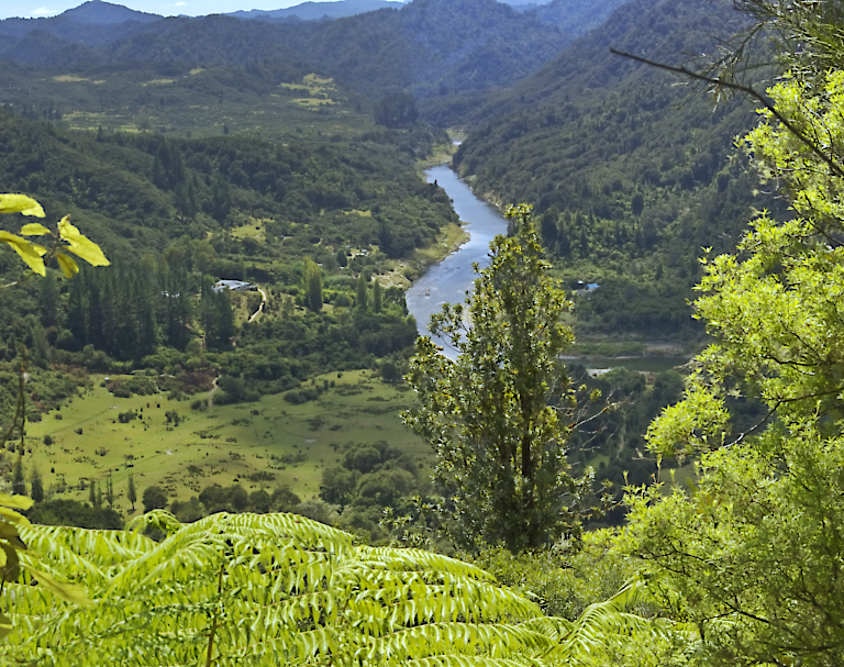
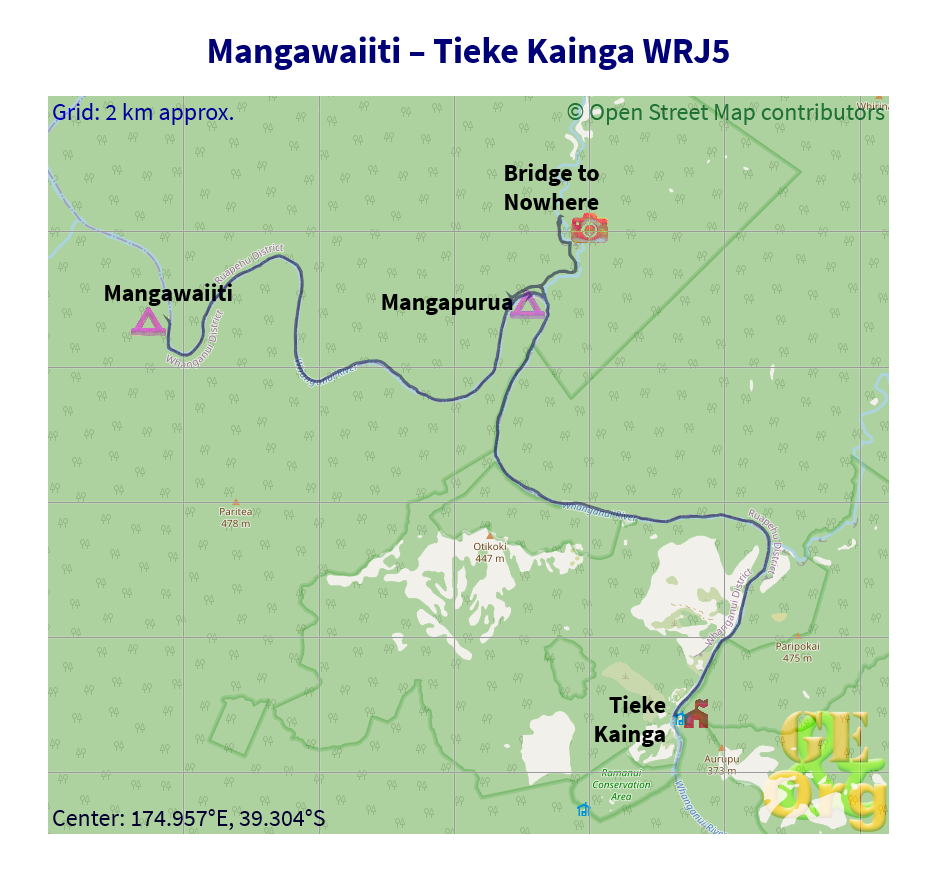
All the food was gradually disappearing & breakfast was quickly dealt with. Then the long trek with the stuff down to the boat, and getting ready to go. Everything worked as planned and I was quite proud of my start before 9:00. Progress was also quite rapid and I was a little surprised when “The Rock” turned up, complete with a cyclist awaiting his jet boat on top. It was much larger than what I had in memory, and much more daunting. How those dozens of Canadians managed to moor here is beyond imagination. Anyway I wanted to do the right thing and disembark at Mangapurua Stream. Had to find it first, it was perhaps a little further than the 500 m mentioned elsewhere. Anyway I was up the creek, and there was a nice landing place where I didn’t need to tie up the boat. Decided I would do some brackets of the Bridge to Nowhere, that meant dismantling the gimbal & tripod (good practice) and with lunch in the bag I set off first for the landing where I had a chat with the cyclist, and then to the Bridge itself. Quite a long walk, but fun anyway. Went to the lookout and took a couple of shots, then onto the bridge. Shots from either side, then lunch as two couples, one German, the other Belgian, then a whole troop of tourists including our cyclist arrived for their lunch with a tour guide.
Slide Show
Click on the image to stop/start the animation
A couple of brackets from the bridge were taken as well, then I was back along the path to the stream. By the way, the sidetrack between the stream and the main track is marked as closed (under construction) and had two very steep step sections more like ladders that had to be taken backwards on the way down. Noticed the jetboat (source of the tour guide & tourists) moored at the mouth of the stream, then set about getting my equipment working on the boat again. Boat had to be dragged a little way to the river, then I was set to go.
Youtube Video
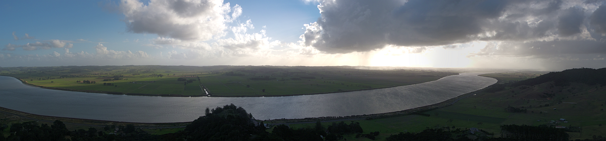
The river here is less vigorous, and the sweeping amphitheaters give way to milder hills. Was overtaken by three jetboats and at the first sight of real farmland (some banks look like they could be or were once used for grazing) Tieke turned up, and I was the first arrival. No sign of anyone present, although cleaning devices for the floor were propped up here and there and all the windows were open. Sent off a spot OK to Gavin, then flicked through some of the pictures. Stability looks good, contrast is quite high, position is also quite good. Dragged all of my stuff up except the tent and at 3:45 claimed a bunk and started today’s chores, which involved airing the sleeping bag, drying some sox and undies, and starting on the diary.
OpenStreetMap
Easy paddling day and a brief walk to Nowhere. GPS quality: 30/30, coverage: 100%
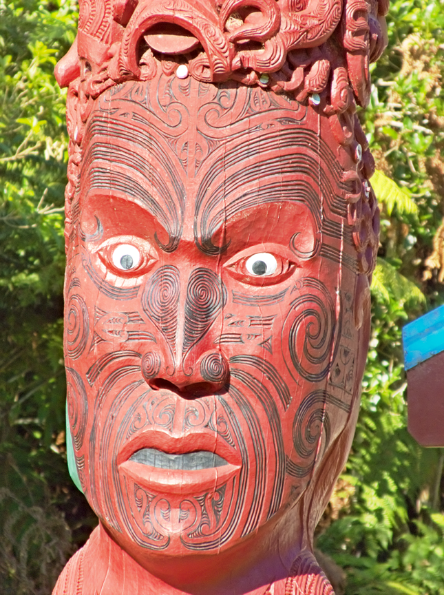
In the meantime the Belgian couple arrived, and bit later the warden, Boyd, who is quite a source of pseudoscientific folklore (Kangen water). Will now see about photographing the faces on the tekoteko before dinner.
More people arrived and Boyd put them all (!) into the dormitories instead of tents, so tents were dried and packed up again. He also provided a powhiri of sorts around 6:00 with little speeches of his own in Te Reo & English, then asked us to contribute a word or two & I took the lead by telling everyone about the birds that I had seen along the way and nearly everyone else followed suite. It was getting quite late for dinner, but mine (rice, instant noodles & tomato for a change) took only twenty minutes and was just as quickly consumed. Chatted away with Manfred and his wife from Zürich and am now fully considering a plan for tomorrow. One set of batteries was marked as “dead” although they must have been full, so the first step apart from boiling water will be to see what happens when I put them into the powerbank again. Then I need a shooting plan and a rapids plan for tomorrow.