Saturday, February 23: Heavy rain overnight, overcast with drizzle in the morning, becoming fine by midday and a bit of sun in the afternoon
Tramping: 34.5 km
Mangaturuturu Hut (Doc, $15)
I had won the general prize the night before of identifying the bird on the back of the $20 bill (karearea) and had two pancakes with frozen blackberries, chocolate and maple syrup. Trevor had also gotten a prize (for knowing the exact number of Doc huts in the country: 956), as well as the medical professor, Margarete as it was her birthday, and it was all served at 7:00. The rest was packing and by 8:30 I was ready to go and see what Whakapapa had to offer.
I could see the Irish ahead of me but they may have taken the side trip to the old hut; after a while I caught up with the Scottish couple I had shared the half bunkroom with last night, and remained with then until the turnoff to the Tama Lakes, which they wanted to try to see & I pushed off to the village. From now on day hikers dominated the track, and I was able to speed along, making it to the i-site in good time for lunch.
Now the bet was on. If the rivers were clear and less than 5 mm of rain were forecast for the next 24 hours I would attempt to reach Mangaturuturu, otherwise abandon the track. Spoke to a Doc person who pointed out that the river crossing about 500 m to the north-west of Whakapapaiti Hut was the critical one; if I could cross there then all the others could be done without difficulty. Rain was forecast @ 4 mm, so that cleared that hurdle. Now for the crossing.
Slide Show
Click on the image to stop/start the animation
The path to Whakapapaiti is very well formed to begin with and quite pleasant through beech forests. One gigantic footbridge marks the end of this track, and the path then becomes more adventurous.
The river crossing just beneath the hut is a major difficulty at any time. There is a bit of boulder hopping at first, but there is no clear ford at the river, so wading is necessary. I fell in a bit and wet the bottom of the pack, the camera bag and myself up to the underpants, and the current was strong. However once across, that hurdle, too, had been passed and nothing was stopping me from reaching Mangaturuturu.
Stopped at the hut for a second lunch break and to squeeze out the sox. I had made it here in just on two hours (two-and-a-half signed) and the further distance was still given as six hours (eight from Whakapapa) giving an extreme ETA of just after 9:00. Of course, it all had to be done well before that because the condition of the track was not have been conducive to night hiking. It was, however, a contingency that had to be prepared for.
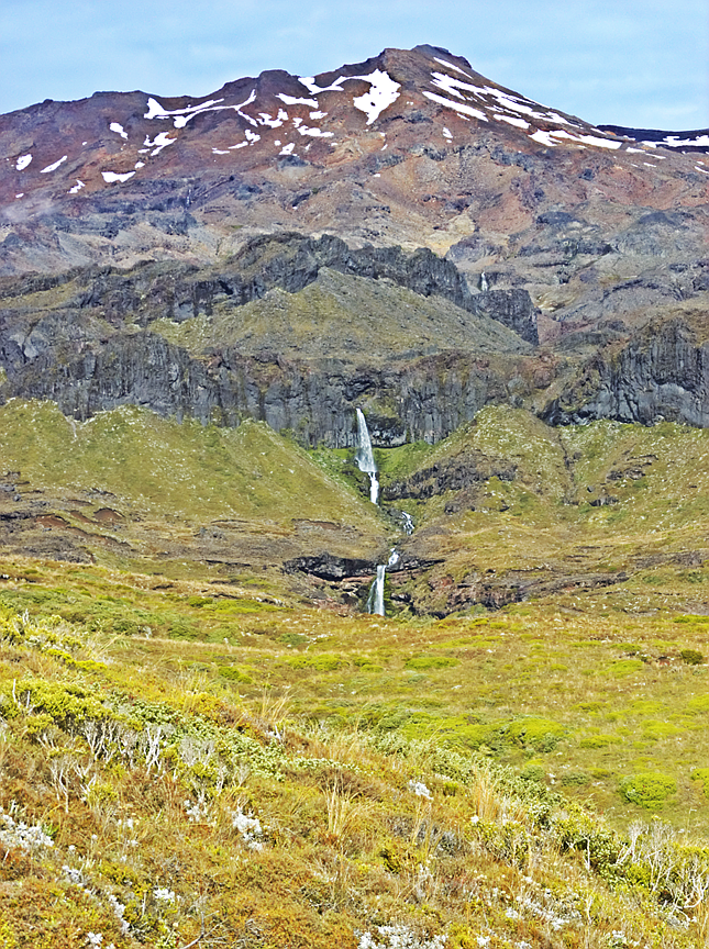
This part of the track is the most scenic with waterfalls coming off the mountain side (at least today after the rain) and much greener valleys than “The Desert”. I had had to turn the camera holster inside out to dry it which meant either carrying the camera in my hand (which was a bit tricky on a couple of down hills) or putting it back into the pack. Will have to do this section again at a more leisurely pace the next time. The valleys that had to be crossed were not so difficult, as the top of the far ridge could always be seen as a destination, which was psychologically motivating. A couple of streams wet the boots again, and there was water on the track, either in the form of puddles or streams, but not much mud. However, the valleys were becoming higher and higher as the afternoon wore on.
I kept checking the GPS for operation and it seemed to have done a fairly good job throughout the day. At around 6:00 and 1600 m altitude I swapped out the batteries and prepared the headlamp for deployment. By now I could see the skilifts at the Turoa field, a hut along the road, and knew that I only had a couple of hours to go.
OpenStreetMap
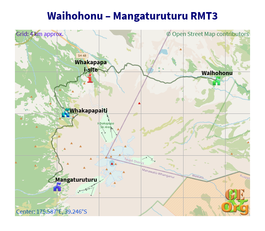
Long trek, great scenery. GPS quality: 30/30, coverage: 100%
After one minor valley the track turns west along a ridge; and in the setting sun the myriad of ridges, volcanic hills and other mountains across the Whanganui Valley as far as Taranaki provide that magic panorama of the landscape melting into the distant light. Fairly soon, Surprise Lake was visible, then also reached along the long boardwalks and stairs; then there were interruptions down mountain streams. I knew that the hut must be somewhere but it eluded me for a bit still. I could see the boardwalk across a wetland, and Ruapehu was beginning to put on a show in the setting sun. If only I could reach the hut while there was still daylight and set up a timelapse!
I had failed to consult the map at the last stop and trudged on as quickly as I could. The Mangaturuturu Stream turned up and I was just beginning to doubt whether I would reach the hut at all when I caught a glimpse of it behind the trees on the further bank. The last stream crossing was done without any rock hopping and I reached the hut @ 7:50. Rachael & Jeff were there already, had a fire going and some water warming, but I first had to change the batteries in my camera and set off a timelapse, which was worth all the effort.
Youtube Video
A short while later an American, Will, turned up, an acquaintance from Waihohonu, who had one the other half of the Round the Mountain Track also in a day. I will have to calculate who did more kms, but it was a crazy effort on both parts. He has his pack down to 5 kg and carries no stove or electronics; he is on the Te Araroa and has taken a side trip along the Round the Mountain for a couple of days.
Some serious rehydration had to be done, as well as dinner cooked, and it was not until 10:00 or so that people were ready to go to bed. A tough day! Possibly a New Zealand tramping record, not only for time, but distance as well. Will has calculated that I did 33 km. Let’s see.
The stars were out in full force and the moon was about to rise behind Ruapehu as the lights went out. Jeff started snoring for an hour or so before Rachael stopped him, then all was silent.
Today’s tramping timetable:
| Where | When |
| Leave Waihohonu Hut | 8:45 |
| Arrive Tama Lakes turnoff | 11:00 |
| Whakapapa (Lunch break) | 12:40-13:05 |
| Whakapapaiti | 15:15 |
| Finish @ Mangaturuturu | 19:55 |