Monday, September 17: Sunny with some high cloud, a little warmer
Hiking: 21.8 km
Marco’s
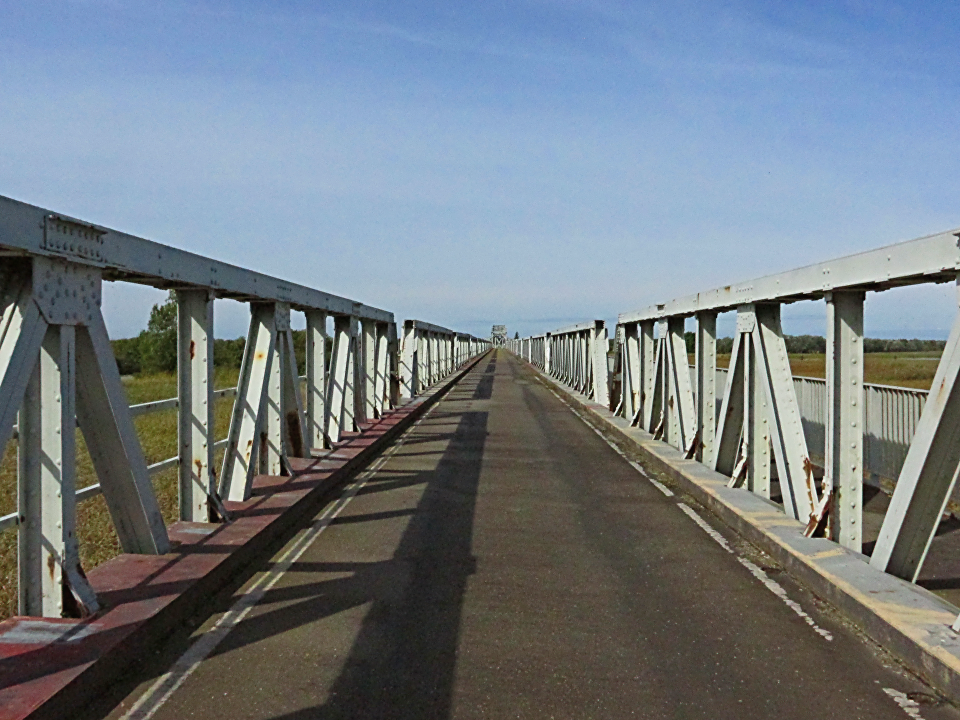
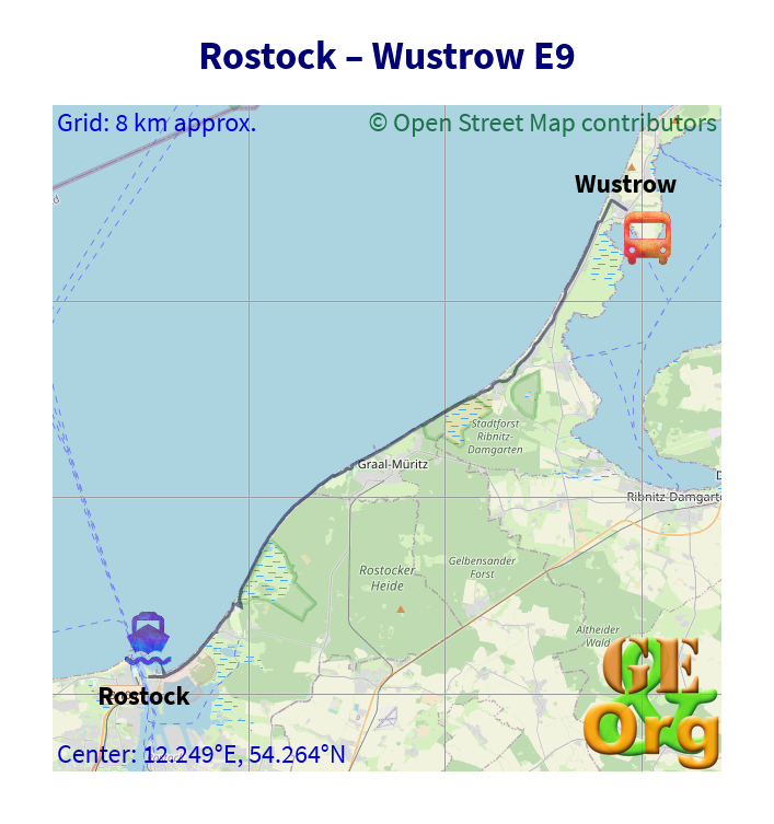
Old Bridge to Zingst
Was a little late off the starting block this morning, still had to get some bread rolls and filling for lunch before breakfast could begin, but that was soon dealt with, and everything packed away for today’s walk. This was going to be some time getting to, but wouldn’t be particularly long. I had gotten the directions by means of a screen shot onto the camera, and with the maps I felt fairly confident this would not be a hard day. Applying the sunscreen was left to be done on the bus.
Damm Gate, BarthBus was reasonably on time and I showed my pass to begin with, with the intention of getting out and Dierhagen Intersection and waiting for the bus to return and buy the full ticket then. But that was not to be. Instead of going via Dändorf and the village (with the long extended return trip to Neuhaus) the bus went to Neuhaus directly, missing out on those two stops. As the driver stopped in Neuhaus, and there was no further advantage to be gained by waiting, I went up and ordered a ticket to Prerow; the driver then realised that he had a passenger with a ticket she didn’t want because she would have preferred to have a return or network ticket for the day, and had a ticket to Zingst that she would rather get rid of. I bought the ticket off her for €6.6 via the bus driver, and he issued her with a new ticket. Do not try this at home. Read more…
Sunday, September 16: Sunny and warmer, although still a little cloud about
Hiking: 25.0 km (with detour to the lighthouse)
Marco’s
Very peaceful setting here, some distance from any road, but the sun shining into the living room window got me to wake up and start doing something with the day, which was turning out to be better than yesterday.
Breakfast was the coffee with some fresh milk, the yoghurt and a bread roll with two slices of meat; then the lunch had to be made up and the pack packed for a satellite day, so apart from the lemonade it was rather light.
The bus seems to run late as a rule here, especially if the bus driver is not 100% with it. Today’s driver accepted my Kurkarte for the whole of the trip (which meant travelling without a ticket for the last three stops). Once in Wustrow I took off for the last km to the beach, and then along the beach for the first hour or so. I saw a map which had the E9 marked on it so I took a photo of today’s section, just in case. Read more…
Friday, September 14: About warm enough for the season, quite sunny with a few clouds
Ani’s (airbnb, €22.8), Rostock
Packing was quite organised today, with the new vanity bags coming into use, and everything being weighed. I cleaned up the flat as much as possible, and even got the ghost lighting to work after having found a manual on the web last night. The only thing that doesn’t appear to be working is the digital cable receiver. For the money: This will record to a hard disk, but not play from it; it will play from a memory stick if the .idx and .meta files are present; it gets totally confused if it tries to read from a card in a card adaptor (meaning it will be in standby, but never wakes up to find the card and start recording). Can’t someone test these things before they go online? I saw one on ebay for under €23, and real seemed to have some on sale next week for just over €30. I’ll see about that in the course of the week.
Anyway, what was forgotten in the packing seems to be very little: The mains-USB adapter (although I have the multi-USB adapter with me just in case), the ipod (last minute rush to get to the bus), and a pen. Hey, I was writing with one of those. That’s about it.
Caught a bus to the station, and there had been an accident at the tram exchange, with one tram spread-eagled across the road while police were out with measuring sticks protocolling everything. I thought the bus might be delayed just getting through the scene, but we were in good time for the train. A couple of minutes delay on the first train to Celle, about ten minutes on the further train to Lüneburg (made the 32-minute wait less demanding), then the trains to Büchen and onto Rostock were pretty much on time.
I was here after just over fifteen minutes walk, rang the doorbell at Ani’s, was surprised that someone answered (Christina and Martin, who are friends of the hostess and are also staying here), went upstairs past a welcoming committee that was smoking in the stairwell. Took a little while to determine where Ms Andres lived (turned out the ground floor, and hers was one of the few flats with a legible name on it), got my key as Christina and Martin made their way off to town.
Headed for the supermarket for something for breakfast tomorrow, found a coke can on the street which was redeemable to €0.25 (it’s come that far! Old man supplementing his pension by collecting deposit cans off the street!) and was back here by 8:00. Have sussed out where the necessary light switches are (with a bit of disco-style psychodelia in the hallway) and will spend the rest of the evening checking the pictures on the camera and charging batteries.
Saturday, September 15: Sunny and warm to begin with, becoming increasingly cloudy, with a drop of rain or two, and cooler. One stronger rain burst as I was waiting for the bus, but that was soon over
Hiking: 30.1 km
Marco’s (airbnb, €53/night)
The room didn’t have much in the way of curtains, and the view was that of some high-rise settlement on a distant hill to the east, which is where the sun rose, and me with it at just on 8:00. The other inhabitants were also motivated to get up and moving around, so that four people in the very small kitchen was quite a crowd, yet we managed all to have our breakfasts and perform our ablutions without so much as getting on anyone’s toes.
I was soon packed and ready to go. The trains were every fifteen minutes, so there was no hurry, but I tried aiming for the 9:18. In hindsight it would have been better to catch one of the trams for the final two stops, because then I would have had a ticket for all the way to Warnemünde at no extra cost, but with some saving in time. By the time I got to the station it was 9:15, and two couples had occupied the two ticket machines and were humming and hawing about what they wanted to do next with them leaving me the only alternative of going to the ticket counter and trying to get a ticket before the train left. Got the ticket, remembered to ask whether it had to be validated or not, and had just climbed to the top of the stairs to see that last of the train leaving. Found a validation machine in good time for the next train.
Once out in Warnemünde I took a very roundabout way to the ferry (puzzled at why there should be two routes, but one went down a tunnel, the other was on level ground. In any case I reached the ferry (with a ticket) as it was about to leave. Took a couple of pictures of a yacht on the short journey, and off on the other side set down the pack to restart the GPS, sort out the glasses, and generally try to make sense of the maps on the camera.
Slide Show
Click on the image to stop/start the animation
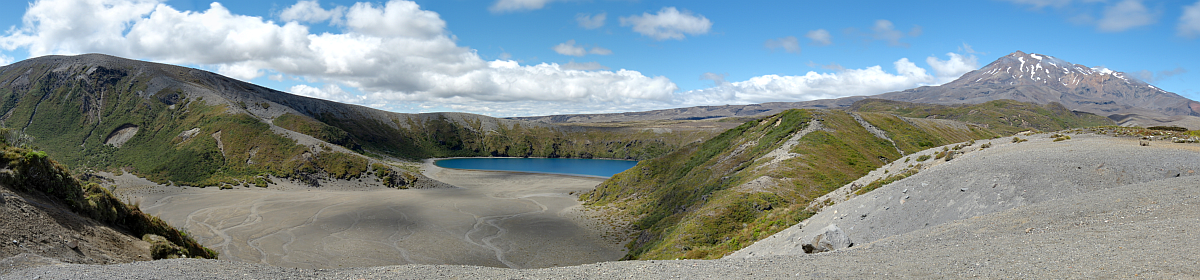
Today was not a day for a lot of markings on the track; on the road into Markgrafenheide a couple of signs showed up, but then as the path left the road, the same symbol was also shown going into town. At a holiday village the signs insisted on going some distance inland before returning to the beach, and here there was a sign that said that the path to Graal-Müritz was either the bicycle path (longer) or the E9 (shorter but 1 km along the beach). I ended up doing most of it along the dunes and then the beach, and there were no signs visible from the beach. Just into Müritz I stopped for lunch, and out the other side I came across a marker again, with a sign that said 14 km from Hohe Düne and 15 to go to Wustrow (after 3:25, at 13:42), which I thought was a bit tight for getting the bus. I tried to keep up the pace for the rest of the track, but it seems like the sign was a little bit biased in the opposite direction (it was in fact 16.3 from Hohe Düne, leaving just under 14 to Wustrow).
By now I was following the bicycle track come what may. The number of walkers decreased bit by bit, and the number of cyclists increased. After reaching Neuhaus and Dierhagen Strand the distances to Wustrow seemed more reasonable and indeed doable without any panic at the last moment.
Access to the beach was measured at around every 200 m, and eventually Wustrow came into view. I ignored the first sign pointing towards the center, because I wanted to reach the pier at least before retiring to the bus, and pretty soon Strandstr was reached, which was the end of today’s walk. I trudged up the street to the main road, found the bus stop immediately and had half an hour to kill, some of which was taken up by eating an apple. Then it started to rain. At first only a couple of drops, but then it was cats and dogs. One woman also waiting for the bus set up camp in the bus stop, followed by two other women, then a couple of bicycles. Swarms of hundreds of swallows passed overhead every now and then, despite the rain, but probably surfing on the wind.
OpenStreetMap
Start on the final stretch along the Baltic Sea. GPS quality: 30/30, coverage: 100%
The bus was late, and the following journey didn’t make up any for time. By the time we had reached Ribnitz, the delay was over half an hour. I had a brief look at a map to refresh my memory of where Marco’s place was, and was soon there. The holiday unit has an entrance at the back of his place, so we walked through past the bunnies and there I was. First thing was to check the internet, couldn’t find the password, but could see a guest access, so I went around the outside back to his place. The password was above the coat rack, the last place I would have thought of (instead of in the useful tips for guests). Anyway got my internet, then set off for the shops to get some stuff for tomorrow.
I had seen a Rewe supermarket on my way to the flat, the nearest Lidl was beyond Wustrow. I managed however to get the full refund for the Lidl cans from yesterday, bought some beer (will have to try out a couple of six packs of Störtebeker’s craft beers just for fun), then with nearly everything set off for dinner.
This was not easy. The Vietnamese place I first tried (Lotus) had three very dysfunctional staff who just weren’t getting anything done. I was left without a menu for the entire time I was seated. Several couples sitting around me had become so bored with waiting for their orders to be taken that they repeatedly opened and closed the menus for a bit of light relief (and in the time I sat there, only one couple’s order was taken). The guy who was collecting the money was having an awfully hard time getting the bills straightened out and one woman came not once but twice to the front counter to pay, and was sent back to her table on both occasions, although it appeared that she had paid on leaving shortly after the second incident. I nabbed the payment guy to ask him to give me one of the menus he was toting around and when he started with, “Just a moment,” I judged it time to leave.
The next place I visited wasn’t much better (Akropolis) – not even the empty table was on offer, nor the place after that: Paganini – the waiter didn’t make much of an attempt to find any space and suggested taking a table outside. Well, smartarse, if I’d wanted a table outside I wouldn’t have gone inside to ask.
The number of available and visible places was becoming fewer. In the end I tried the Hanse Grill (Südlicher Rosengarten) which after some discussion with the waiter I was able to get a moderate-size döner with salad, bread and a beer for €9. That will do. Then it was back to the supermarket for tomorrow’s yoghurt and two bottles of lemonade for the walk.
Was back here in time for the news. The better weather is due at the beginning of the week. Nice, but very small place here, will do for one, and can use the Kurkarte to get a little off the bus tickets in the following days.
Sunday, July 29: Cloudy to begin with, then hot & sunny
Hiking: 29.6 km
Home
It had rained some more during the night, but the day started clearing after a very short break. I got all my stuff together (including the two new towels) and left Kevin’s keys on the desk, as he had requested some time last night. At least no wild party girls or couples having sex in the night.
I was soon down at where the track begins and noticed that there was a white-blue-white sign with “11” on it, so about the time my recorded track had parted company with this 11, I chose to join it to see where it went. At least it remained fairly green for a while, and I noted von-Luck-Str and Spanische Allee turning up. I followed the marking over the street, and then it was briefly lost until I went through a small tunnel under the railway to Schlachtensee itself, and took up the track again. I had wondered about a couple that I had met along the way dressed in bathrobes, but this lake is a certified swimming lake and plenty of people were doing just that. Read more…
Saturday, July 28: Still very hot, one thunderstorm in the early evening, a little cooler
Hiking: 37.2 km
Kevin’s
I managed to get up on the dot of 8:00 and breakfast (one roll with sausage, coffee) was had, lunch made and everything packed up for the day in 40 minutes. I was down to the station a little earlier and correspondingly earlier into Potsdam, where I had a bit of a look around. Bus to Ferch was fairly full, but the going was smooth and we were soon in the place itself. A march around the block brought me back to the bus stop where the walk proper begins.
Must be a lovely place to spend a summer in. The village center was signed, so if that were doable in the time you could climb up to it, or you could remain on the level and aim for the stop at the camping ground, another ten minutes along. Read more…
Friday, July 27: Day n of the scorcher, very hot and sunny to begin with, but the cloud varied quite a bit. Signs of a thunderstorm towards evening
Hiking: 31.8 km
Kevin’s
I had been woken at around 3:00 by someone having a very hot shower, and someone else (the boyfriend) vaping in the lounge. I hope the shower wasn’t meant as contraception, although it looked very much that way (especially at that time, and with the vape). I couldn’t sleep much past 7:30, and so started on my preparations for the hike.
The smaller roll was had for breakfast and the larger one set up with bell pepper sausage for lunch. That with now four litre bottles of water was packed away and I was ready to go with the first set of trains. Had to stop by the bank for some cash, but even then I took a set of trains one too early, and a good thing, too, because it took most of the twenty minutes waiting time trying to ascertain where the 580 bus left from (all other bus lines appeared to start with “6”). Finally nailed down the bus, asked the driver and identified the temporary bus stop that he was planning to use.
There must also have been an issue with traffic around the forest fire, because as we were about to enter Lehnin, everybody seemed to be wanting to exit the motorway, and a gigantic traffic jam ensued. Our bus driver did the best he could, and we had only about ten minutes’ delay in the end. Then it was off onto the track again. Read more…
Thursday, July 26: Hot and sunny, a little wind, very few clouds
Hiking: 33.3 km
Kevin’s (room in student dorm shared flat in Berlin, €22.7 a night, will be a bit of a challenge)
Was up very early, despite all the attempts of the host to darken the windows (dark drawer, venetian blind, curtains), as the room had become quite hot. Down at breakfast, the only other guest was there as well indulging in his habit of addressing the phone. Anyway, breakfast was three bread rolls, coffee, and the usual assortment of sausage and cheese. I put one bread roll away for lunch, proceeded to pay, and was down at the market square getting a GPS fix before 9:00.
The walk around town to the north should really be done the day before, as it is only about 2.0 km longer. The street to come back down is Rosa-Luxenburg-Str., and that is quite well marked. I took hydration breaks at Springbach-Mühle and Lütte, and lunch was on the plan just outside of Dippmannsdorf. Here there is a further pub which is now called “Paradies”. The sandy track is quite hard to negotiate as dry as it is, and the Scots pine and/or larches throw about as much shadow as the eucalypt. In the meantime there were denser forest areas which were cooler. Read more…
Wednesday, July 25: Very hot and sunny, not much wind, a few clouds
Hiking: 30.4 km
Hotel zum Alten Brauhof, Straße der Einheit 16, Bad Belzig, double as single (€45)
The night was somewhat cooler, but that meant having to keep the windows open, and I could hear one or two mozzies looking for dinner. The sun was already quite hot, and although Bernd’s invitation for breakfast in the garden was hard to resist, I had to get the umbrella in the right position so that I wasn’t already being fried at 8:00.
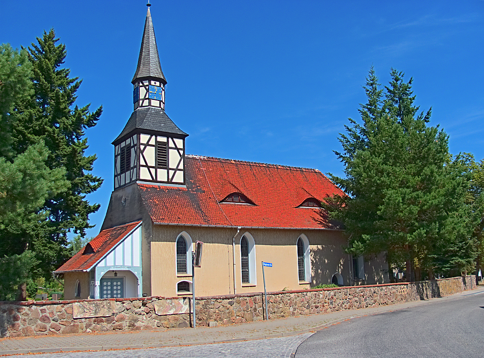
I had all my stuff together, except for the small change I had put somewhere inexplicable – it turned up on one of the wardrobes – warning to self: Put all objects on low lying tables where they are visible! Then I was off down the track some distance from the road and alongside Raben with various amounts of shade. Read more…
Tuesday, July 24: Hot and sunny throughout, a couple of clouds in the late afternoon
Hiking: 32.4 km
Bernd’s, Rädigke, single room upstairs with shared con (€27.3, airbnb)
Had to be up half an hour earlier to get everything done on time for the early train. Breakfast was dealt with, then it was off to the supermarket for two bread rolls and two bottles of orangeade, then back to René’s to make the lunch, clear up the room, pack everything away, and I was well in time to take leave of René, and head off for the station.
Guy at the one ticketing machine seemed to be asking for extra service, so I had the time to go to the cash desk and buy a real ticket. On the platform the end half of the train didn’t seem to be taking passengers, so I moved up forward and got a seat with a view in order to get a good sat fix for the GPS. Only fly in the ointment was that the ipod was not giving out any sound, will have to look into this in detail. Otherwise it’s bye-bye Apple.
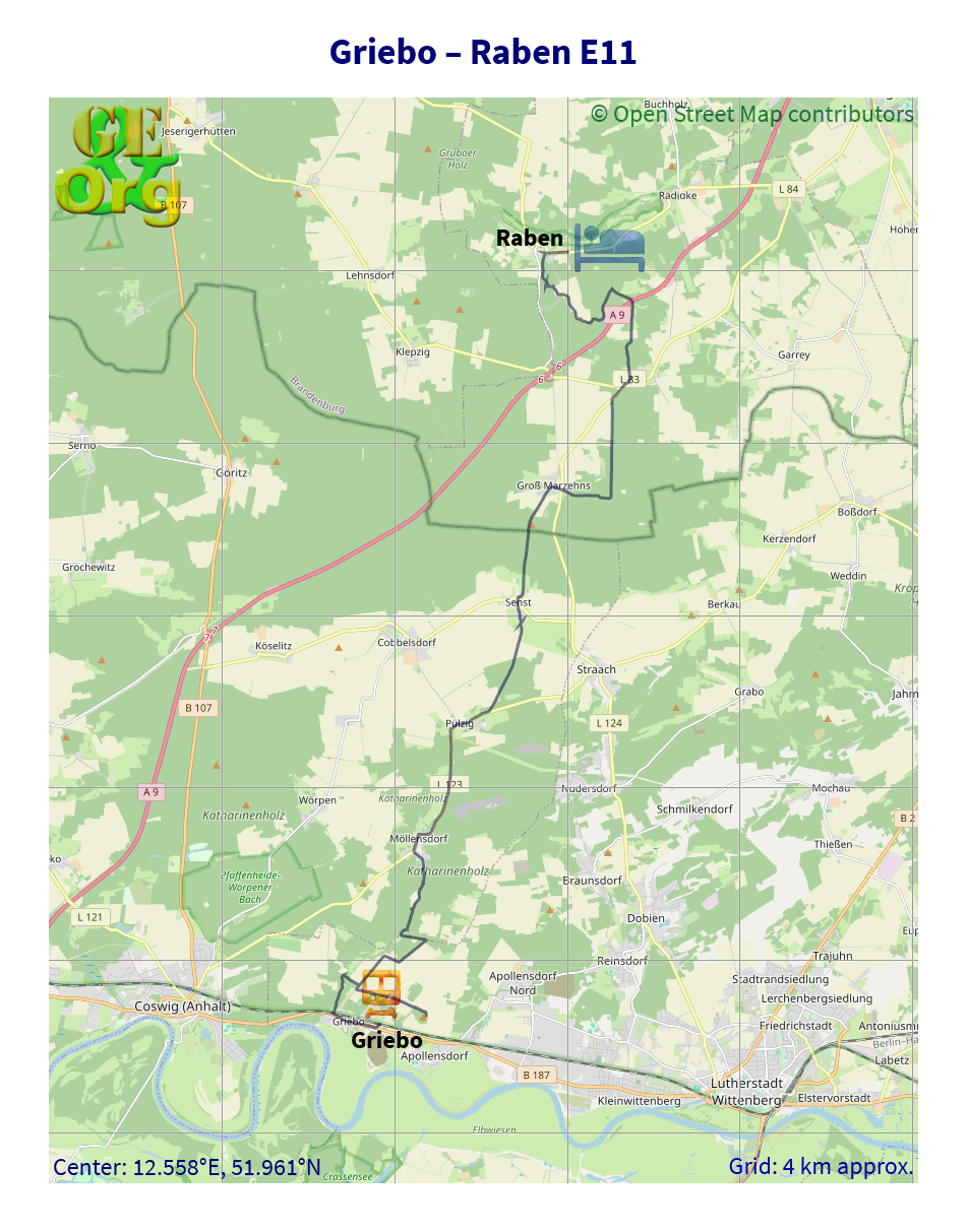
The journey was soon over and I walked back along the road to the track start. This is where the major error occurred: I took up the Luther Path (even though it was not carrying the E11 signs any more) and ended up heading towards Wittenberg, which I really noticed only after about 2.5 km. I should have looked very closely at the start before beginning, but a sign giving 4.0 km to Möllensdorf was too tempting. Anyway I had to traipse back over the hot fields, and try to make my way north. This sort of worked, but involved some dedicated bushbashing and after 2½ hours I finally found a sign to Möllensdorf (only 0.9 km), but this had taken seriously much more time than necessary.
To find a way forward, I elected for the road from Möllensdorf to Pülzig (no signs for the E11 were visible at all, though) and on arriving there saw that I would have to try walking from my notes, as there was no further advantage to be gained from walking along the road. Pretty much on the dot of the 400 m I had estimated to where the track leaves the road, there was in fact a track with a white-blue-white marking which led directly to Senst, where I stopped at a bbq/playground for lunch.
Slide Show
Click on the image to stop/start the animation
Continuing through Senst and along the street towards Groß Marzehn, the appearance of a field followed by a forest made sense in my notes, but not a single sign for a while, until the border with Brandenburg was reached. Then all the signs in the world turned up. Firstly, the white-blue-white signs appeared regularly from now on, as did proper signposts with realistic distances on them. What a change! For the first time in about 100 km there was a sense of confidence in the track. I could now see that I would arrive at Burg Rabenstein at around 4:00. However, this track does deviate from the track that I have a copy of, most notably between Groß and Klein Marzehn, where the real track follows a forest path, rather than the road, and there is even a new section just before Klein Marzehn, which still has to be paved.
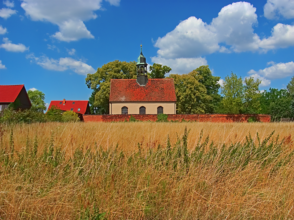
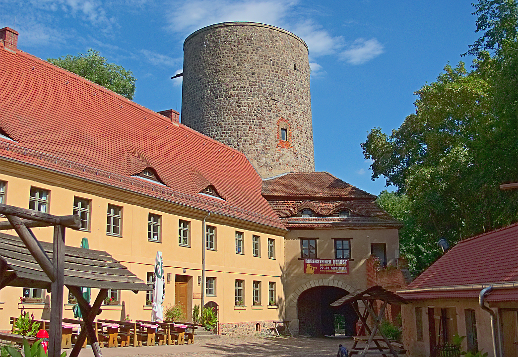
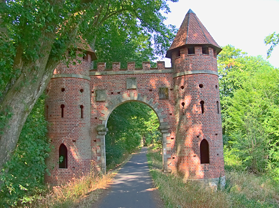
Along the way to Rabenstein, the Million Bridge is a very imposing, gigantic Roman arch made of bricks to carry the motorway. A short time later the castle was reached, where it was time for a shandy, before the last kms into Raben. I was set on walking the whole way, but Bernd had told his acquaintance he was supposed to be meeting for coffee that he was expecting me, and after just on a km of road walking, a car pulled up and asked me whether I was staying with Bernd, and she took me all the way to his house. I had done enough walking anyway.
OpenStreetMap
Into Brandenburg. GPS quality: 30/30, coverage: 100%
Bernd is a very pleasant older gentlemen with motor center damage from a stroke affecting the left arm. He was tending to his expansive garden when I arrived and I surprised him a little. He is very much involved with bringing some culture to this very small village (150 inhabitants) and related his encounter with Paul Oestreicher to me. Now, Oestreicher and I have at least one common acquaintance (Lenore Ryan), apart from his connection with Dunedin and Karl Popper who was also in his cohort of Jewish refugees taken up by New Zealand. What intrigues me is that I had never heard of him before.
Anyway, a short shower had to be taken, some sox washed, and then the question of dinner arose. The only pub in the village (which doubles as its library) was open, and Bernd was a guest of honor, so the choice had already been made for us. I had a pork steak with onions, chips and salad with a wheat beer for €15 (Gasthof Moritz), and the spacious courtyard was a tranquil end to the day, with a couple of families turning up from the local camping site. Bernd took me for a brief guided tour of the place, showing me how to avoid the road to get back onto the E11 tomorrow morning.
In the meantime Bad Belzig had organised an hotel for €45, which is the best of a tight situation, and I will have to see tonight about booking something for further along the track. But at least the track is there for once.
Monday, July 23: Hot and sunny, with some wind every now and then, a couple of clouds in the afternoon, but perfectly clear in the evening
Hiking: 30.0 km
René’s
Didn’t feel I needed to get up too early, but by around 8:00 I was up and about, had my breakfast, took off to the supermarket for today’s soft drinks and lunch (forecast was for well over 30°), made up the lunch here and was ready to go just before 9:30. No train to catch this morning, but went through the station anyway as an alternative, through the center of town and out down the track from yesterday. Eventually found a blue and white marker and a little after that the official looking signs, whereby it must be commented that for most of today’s route the E11 and the Luther Path were companions yet again. Let’s see how long this is good for.
Decided to rely as heavily as possible on the signs today, but had my diary there just in case. Just before the Luisium the markers ceased, and I failed to identify the one cafe I past, so on it was through this very special landscape they have here, part castles and gardens, part wildly romantic pastures set in cultured forests. Many a dead tree beckoned to be photographed. Finally a signpost showed up, putting all of today’s tracks onto one sign, including the Elbe Cycle Path, so that in case I was lost again, I would have to follow that. Plenty of cyclists around as well. Read more…